Posts

Showing posts from March, 2025

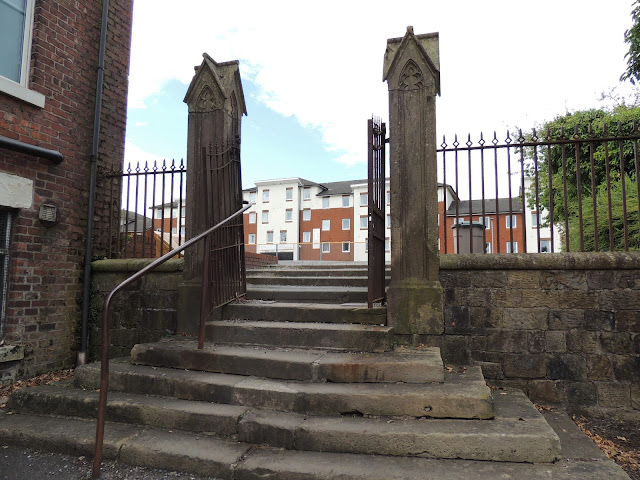
Whinfield House Stone Gateposts

Image
Whinfield House Stone Gateposts Whinfield House was originally the home of Henry Newsham Peddar .  The house was later occupied by Edmund Robert Harris .  The only evidence remaining of Whinfield House are a pair of stone gateposts that are still in situ.  They currently look like this. Whinfield House Stone Gateposts Whinfield House Stone Gateposts Whinfield House Stone Gateposts Whinfield House Stone Gateposts It is likely that they have been moved slightly from their original position.  The road was widened along Pedders Lane.  The Ordnance Survey Six inch scale maps from the end of the nineteenth century show a benchmark.  This is possibly on the gates.  Georeferenced maps, comparing a modern day satellite image to the maps, appear to have the benchmark in the middle of the modern road.  That being the case, it seems that they have been moved further up the former Whinfield House driveway in a north-westerly direction. Whinfield on a Lat...
Gateposts from the Holy Trinity Church

Image
Gateposts from the Holy Trinity Church All That Remains of the Trinity Church.  The Holy Trinity Church was on Trinity Square.  The Church was demolished in 1951. The black and white photograph, from the Lancashire County Council 'Red Rose Collections', shows the main entrance.  Whilst the gate pillars are the same as the ones that remain, they are not the same ones.  The entrance/exit features that I have photographed are left from what would have been considered the rear of the church on the southwest corner, leading down to Trinity Place. The Holy Trinity Church, on Trinity Square, was demolished in 1951    Extract from Ordnance Survey Town Plan of Preston in 1848 (NLoS) The following extract is taken from ' A Handbook and Guide to Preston ' by William Pollard 1882: This Church is situated on a site known as Patten Field, Snow Hill, approached from Union Street, Friargate. The first stone was laid by Sir Henry Hoghton, Bart., in the year 1814, and in the...

Legal Quay Boundary Stone at Broadgate

Image
Legal Quay Boundary Stone from 1844 at Broadgate 1844 stone which marked the east boundary on Dairies' Wharf of the Legal Quay, Preston.  It was situated on the north bank of the Ribble a few hundred yards from Penwortham Old Bridge.  Marked LQ EB 1844. The western boundary stone has never been found. 1844 stone that marks the East Boundary of the Legal Quay Legal Quay Boundary Stone Marked LQ EB 1844 at Broadgate ~ Local history buffs were pleased to see a boundary stone for the old port of Preston in Lancashire, opposite the junction of Broadgate with Meath Road, had been preserved, following some River Ribble flood defence improvement work. The port had to have clear boundaries for Customs purposes, and these were established in 1844.  This marker is for the eastern boundary (see EB inscribed on the front of the stone) of the legal quay (LQ on top).  Unfortunately, the western boundary marker had been lost some time ago.  If anybody is familiar with the city,...