Legal Quay Boundary Stone at Broadgate
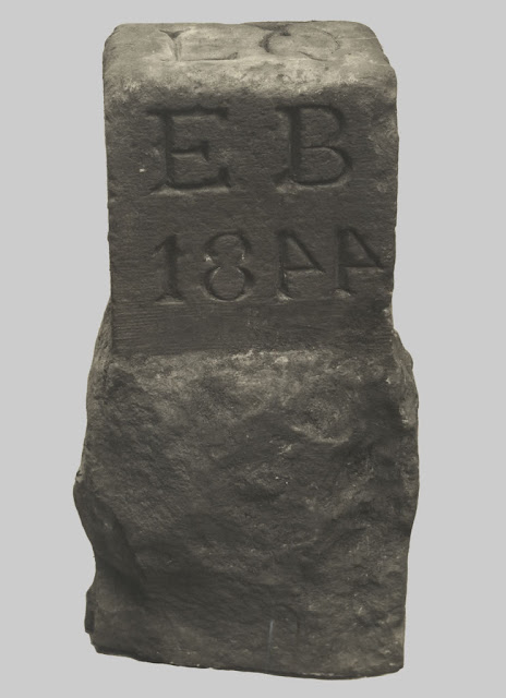
Legal Quay Boundary Stone from 1844 at Broadgate
1844 stone which marked the east boundary on Dairies' Wharf of the Legal Quay, Preston. It was situated on the north bank of the Ribble a few hundred yards from Penwortham Old Bridge. Marked LQ EB 1844. The western boundary stone has never been found.
 |
| 1844 stone that marks the East Boundary of the Legal Quay |
 |
| Legal Quay Boundary Stone Marked LQ EB 1844 at Broadgate |
~
Local history buffs were pleased to see a boundary stone for the old port of Preston in Lancashire, opposite the junction of Broadgate with Meath Road, had been preserved, following some River Ribble flood defence improvement work.
The port had to have clear boundaries for Customs purposes, and these were established in 1844. This marker is for the eastern boundary (see EB inscribed on the front of the stone) of the legal quay (LQ on top). Unfortunately, the western boundary marker had been lost some time ago.
If anybody is familiar with the city, the docks that you can see today didn't appear until 1892. The town had operated as a port for many centuries before that.
Nobody is sure why the fours are in reverse.
Location: 53° 45' 2.48" N, 2° 42' 56.31" W
 |
| The Legal Quay Boundary Stone can be seen at Broadgate |
 |
| The Legal Quay Boundary Stone Marked LQ EB 1844 can be seen at Broadgate |
 |
| The Legal Quay Boundary Stone Marked LQ EB 1844 can be seen at Broadgate |
Legal Quay Boundary Stones were tied to customs regulations and anti-smuggling efforts, with their origins rooted in several key acts of parliament regulating trade and customs duties.
Origins and Early Legislation
Customs and Duties Regulation Act (1558) – The first formal system for managing customs was introduced under Queen Elizabeth I. This act created specific ports and "legal quays" where goods could be lawfully unloaded and cleared through customs.
Navigation Acts (1651–1663) – These acts under Oliver Cromwell and later Charles II restricted the import and export of goods to British ships and designated specific ports (legal quays) where such trade could take place.
Customs Act (1660) – This reinforced the Navigation Acts and established strict rules about where goods could be landed. It also introduced bonded warehouses and penalties for unauthorized unloading.
London Legal Quays Act (1663) – This formally defined legal quays along the River Thames, with the concept expanding to other ports through later legislation.
Customs Consolidation Act (1853) – This was the most significant act affecting boundary stones in the nineteenth century. It consolidated previous customs laws, defined the exact locations where goods could be imported or exported, and authorized the installation of boundary stones to mark the limits of legal quays.
Purpose and Function
Legal Quay Boundary Stones physically marked the extent of areas where goods could be landed and cleared by customs officers.
Any attempt to offload goods outside of these boundaries was treated as smuggling and subject to fines, confiscation, or prosecution.
The stones were often inscribed with the date and authority (e.g., the Board of Customs) to reflect their legal significance.
The Customs Act of 1844 (7 & 8 Vict. c. 56) was a key piece of legislation that reinforced the earlier establishment of legal quays. This act clarified and reorganized the administration of customs boundaries and formally defined legal landing places at various ports, including Preston.
Context for Preston's Legal Quay
Preston became increasingly important as a port in the early 19th century due to the growth of trade linked to the Lancashire cotton industry and expanding maritime activity along the Ribble.
The designation of a legal quay in 1844 likely followed the formal recognition of Preston as a customs port, ensuring that all imported goods could be taxed and controlled.
The Eastern Boundary Stone would have marked the limit where goods could lawfully be landed and cleared by customs officers.
The boundary stone would have been set under the authority of the Board of Customs, which was responsible for managing legal quays and enforcing customs regulations.
~
Further reading and sources of information
Boundary stone, Legal Quay, Preston from the Lancashire County Council Red Rose Collections
https://redrosecollections.lancashire.gov.uk/view-item?i=214094
.
Broadgate, Preston circa1907. Man standing next to a stone marker, originally one of two boundary markers, installed in 1844. Taken from the Robinson Family album via the Preston Digital Archive
https://www.flickr.com/photos/rpsmithbarney/24493621343
.
~


Comments
Post a Comment