Posts

Preston History Map

Image
Preston History Map The Preston History Map Website, which is currently running on 'Blogger', is designed to provide background information to support the ' Preston History Interactive Map ' that is hosted on uMap. The map is not intended to be an exhaustive or fully comprehensive list of historical places in Preston.  It is a map of historical landmarks, interesting objects and notable sites related to Preston's history.  Many of the items or landmarks are perhaps the ones that often go unnoticed and don't regularly feature in other works about or references to Preston's past. ~ The Preston History Map See full screen ~ The link to the  Preston History Interactive Map  map is here: https://umap.openstreetmap.fr/en/map/preston-history_1126258 ~  

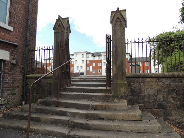
Whinfield House Stone Gateposts

Image
Whinfield House Stone Gateposts Whinfield House was originally the home of Henry Newsham Peddar .  The house was later occupied by Edmund Robert Harris .  The only evidence remaining of Whinfield House are a pair of stone gateposts that are still in situ.  They currently look like this. Whinfield House Stone Gateposts Whinfield House Stone Gateposts Whinfield House Stone Gateposts Whinfield House Stone Gateposts It is likely that they have been moved slightly from their original position.  The road was widened along Pedders Lane.  The Ordnance Survey Six inch scale maps from the end of the nineteenth century show a benchmark.  This is possibly on the gates.  Georeferenced maps, comparing a modern day satellite image to the maps, appear to have the benchmark in the middle of the modern road.  That being the case, it seems that they have been moved further up the former Whinfield House driveway in a north-westerly direction. Whinfield on a Lat...

Gateposts from the Holy Trinity Church

Image
Gateposts from the Holy Trinity Church All That Remains of the Trinity Church.  The Holy Trinity Church was on Trinity Square.  The Church was demolished in 1951. The black and white photograph, from the Lancashire County Council 'Red Rose Collections', shows the main entrance.  Whilst the gate pillars are the same as the ones that remain, they are not the same ones.  The entrance/exit features that I have photographed are left from what would have been considered the rear of the church on the southwest corner, leading down to Trinity Place. The Holy Trinity Church, on Trinity Square, was demolished in 1951    Extract from Ordnance Survey Town Plan of Preston in 1848 (NLoS) The following extract is taken from ' A Handbook and Guide to Preston ' by William Pollard 1882: This Church is situated on a site known as Patten Field, Snow Hill, approached from Union Street, Friargate. The first stone was laid by Sir Henry Hoghton, Bart., in the year 1814, and in the...

Legal Quay Boundary Stone at Broadgate

Image
Legal Quay Boundary Stone from 1844 at Broadgate 1844 stone which marked the east boundary on Dairies' Wharf of the Legal Quay, Preston.  It was situated on the north bank of the Ribble a few hundred yards from Penwortham Old Bridge.  Marked LQ EB 1844. The western boundary stone has never been found. 1844 stone that marks the East Boundary of the Legal Quay Legal Quay Boundary Stone Marked LQ EB 1844 at Broadgate ~ Local history buffs were pleased to see a boundary stone for the old port of Preston in Lancashire, opposite the junction of Broadgate with Meath Road, had been preserved, following some River Ribble flood defence improvement work. The port had to have clear boundaries for Customs purposes, and these were established in 1844.  This marker is for the eastern boundary (see EB inscribed on the front of the stone) of the legal quay (LQ on top).  Unfortunately, the western boundary marker had been lost some time ago.  If anybody is familiar with the city,...

Preston Abstinence Memorial

Image
Preston Abstinence Memorial Located in Preston Cemetery, this memorial, erected in 1859, commemorates the success of the Teetotal Movement. Preston was an early centre of the Temperance movement - the campaign against alcohol, which was the major mass-movement social campaign of the nineteenth century.  At a meeting of the Preston Temperance Society in September 1832, the principle of 'Total Abstinence' was adopted.  The memorial is surrounded by monuments to Temperance activists, including Joseph Livesey , the 'Father of Teetotalism'.  There is also a monument to Edward Grubb, the last survivor of the 'Seven Men of Preston',  who signed the first 'Total Abstinence' pledge in 1832.  Grubb is actually buried in Harrogate, but there is a stone in Preston Cemetery that reproduces the inscription from his gravestone. Preston Abstinence Memorial. Preston was a centre of the Temperance movement Uncovering England’s Secret and Unknown Memorials During 2018 His...

Cattle Market Gate Pillar

Image
Cattle Market Gate Pillar The Gate Pillar from The Cattle Market  The Gate Pillar is the last remaining evidence of Preston’s long gone cattle market.  As well as being a cattle market, it was also well know for trading shire horses.  The Cattle Market was built next to Brook Street in 1867, on Thursday 24th October specifically, with an Auction Mart later being erected in 1898.  E. G. Hothersall and Sons Ltd. leased the site from the Council.  The Cattle Market was sold to Kendal Auction Mart Ltd. in October 1983. It is near to The Brook public house, which was formerly known as the Cattle Market Hotel or the’ big house’ to locals.  The site of the former cattle market land now accommodates housing. Former Cattle Market on Brook Street seen on early 20th century OS Map Former Cattle Market on Garstang Road seen on mid 19th century OS Map. According to Anthony Hewitson's 'History of Preston', it was paved and pens were erected to contain the hundreds of cat...

Sculptor Thomas Duckett's Gravestone

Image
Sculptor Thomas Duckett's Gravestone By Peter Smith of Preston History In 1878 The Preston Guardian reported the death of the sculptor Thomas Duckett, whose most famous work is now probably the Peel statue in Winckley Square. Thomas was born in 1803, the son of Richard Duckett, a Preston auctioneer. He was apprenticed as a plasterer in Preston, before moving on to work as a wood carver and sculptor with firms around the North West, including Gillows, the famous firm of furniture manufacturers in Lancaster. He returned to Preston in the 1840s with his second wife, Winifred, and set up a studio at 45, Avenham Road. It was there that he worked on his most important commission, the statue of Sir Robert Peel. He also produced numerous marble busts of prominent Prestonians, many of which were later displayed in the Harris Museum. Other work included architectural commissions, including the Royal Coat of Arms that adorns the entrance to Fulwood Barracks. In the photograph by Robert Pates...

Preston Bus Station

Image
Preston Bus Station Preston Bus Station was built between 1968 and 1969 in the Brutalist architectural style and opened in 1969.  It was designed by Keith Ingham and Charles Wilson of Building Design Partnership (BDP) in collaboration with the engineers Ove Arup & Partners.  It is known for its distinctive Brutalist architecture, featuring a long curved façade with ribbed concrete panels and an expansive interior designed to handle high passenger volumes. At the time of its completion, it was one of the largest bus stations in Europe, with 80 bus bays and an integrated multi-story car park. Threat of Demolition and Listing By the early 2000s, Preston Bus Station faced uncertainty due to its deteriorating condition and discussions about redevelopment in the city. In 2012, Preston City Council planned to demolish the station, arguing that it was too costly to maintain. However, the decision sparked a significant public outcry, with conservationists and architectura...